
Posts Tagged ‘Cliff Mass Weather Blog’

A New View of Seasonal Changes
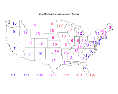
Doesn't it seem like the warmth of spring and the comfort of summer takes an eternity to occur here in the Northwest? (and astronomically, today is the first day of spring by the way). In this blog, I am going to show you ...

The U.S. Fallen Behind in Numerical Weather Prediction
It is a national embarrassment. It has resulted in large unnecessary costs for the U.S. economy and needless endangerment of our citizens. And it shouldn't be occurring.What am I talking about? The third rate status of numerical...

The Revenge of La Nina
Forecast Update and More on La Nina on KPLU at 9 AM Friday or online.Last winter we were securely in La Nina conditions and the region experienced a miserable, cold, wet spring that lasted into mid summer. Horror to all soccer and Lit...

Why is it so hard to forecast lowland snow?
Meteorologists can get windstorm forecasts right nearly all of the time. We hit the record high temperatures in July 2009 nearly dead on. We can give you a skillful forecast of a marine push in the summer.But snow forecasts, although improv...

Major Storm Hits
This storm has so many interesting and intense features I just wanted to update everyone on the action. Here is the latest infrared satellite photo--simply impressive. You can see the swirling clouds around the low center, which is now cros...

Storm Update
Its showtime. The coastal storm is now rapidly intensifying offshore and winds are increasingly over the coast and over NW Washington. The latest runs indicate a similar path as previous model forecasts, with the low crossing the nort...

Major Coastal Storm
Forget the snow showers and other minor weather annoyances. We got bigger fish to fry. A major cyclone will rapidly develop on Sunday and then move northward off our shore, crossing the northern portion of Vancouver Island. ...

Lenticular Clouds
Today there were wonderful displays of lenticular clouds (a.k.a. mountain wave clouds) downstream of both the Olympics and Mt. Rainier. Here are a few photos to enjoy. First one from the cam on top of my building, facing towards...

Will You See the Aurora Tonight?
I have gotten several emails about this, so let me provide some brief guidance. The short answer: probably not.There was a major solar event yesterday and with clear skies several of you saw a nice display last night. In fact, Greg Jo...

A Potential Source of K-12 Science and Math Teachers
I have an idea...tell me whether its crazy.The U.S. has a substantial problem with securing enough K-12 teachers with good knowledge in STEM (Science, Technology, Engineering, and Mathematics) subjects (one study of this problem). This prob...

Double Convergence Zone and Snow Hits the Area!
As last night's run correctly forecast, the front did not bring any snow to the lowlands. As noted yesterday, it was a really interesting situation in which a small change in the configuration of the front caused a huge change in the snow predict...

Snow Threat Evaporates
I just took a look at the latest model runs---both the UW and NWS models--and I had quite a shock. The lowland snows suggested in the previous model runs were GONE. To illustrate, here is the 24-h snowfall for the period ending 4 PM M...

Lowland Snow Timing
Sunday morning's model runs are holding with a pulse of snow tomorrow morning and early afternoon with the front. 0 to 2 inch for most, but some could get more. Here are the latest forecast output for the 3-hr ending 10 AM.This run shows pr...

One Last Shot at Lowland Snow and a Salty Story
We are running out of time for lowland snow. As I have noted in earlier blogs, we have had significant lowland snows the first week of March, but after that it becomes increasingly rare. But with that said, the current forecast ...

New Weather Feature: The Strait of Juan De Fuca Cloud Line
Sometimes one observes a feature that is a bit unusual and one was obvious today--a line of clouds and precipitation down the Strait of Juan de Fuca that extended across northern Puget Sound. Here is an image from the Camano Island radar at 6:54 ...

Wet Snow and the Mt. Rainier Convergence Zone
Many of you have noticed some wet snow mixed with the rain--even down to sea level. However, the heaviest accumulations occurred where the models suggested: southeast of the Olympic Mountains from Shelton to Silverdale to Quilcene. Th...

Lowland Snow?, Thank You, and The Seattle Times Does it Again
We are now thoroughly stuck in a La Nina pattern, cold and occasionally wet. The mountains are going to get several more feet this week...pretty much guaranteed...but there is also a possibility of some lowland areas....particularly southeast of ...

Puget Sound Convergence Zone Snow
We have a fairly strong convergence zone going on, with a moderate precipitation rate, plus much colder air over us--the result has been some light snow, particularly places that have a little elevation.Here is the latest radar....in fact, we have two ...

Lowland Snow Showers, Cold Air, and Strong Winds
A lot of action coming up, including a good chance that some lowland folks will spot a few snowflakes. (Note to TV stations: no big lowland snowstorms!!)A strong Pacific front is approaching us now, behind which there is some cold air.  ...

The Spada Lake Anomaly
There is a precipitation anomaly around here that is rarely discussed.In many ways, it is the anti-Sequim, anti-rainshadow.A place of extraordinary precipitation near Puget Sound.I am talking about the Spada Lake anomaly.Let us begin by talking about t...

Heavy Rain, Avalanches, and Reduce Threat of Lowland Snow
While central and western Puget Sound experienced a nearly rain-free day, very heavy rain has struck the western slopes of the Cascades. Take a look at the current upper level pattern (see below)--one with a broad ridge over the easte...

Chance of Snow Next Weekend?
I have gotten about a dozen emails the last few days asking about the potential for snow next weekend. I am going to break my normal "120 hr rule" (don't talk about forecasts for more than 5 days out because uncertainty is so large). Yes, t...

Big Winds in the Morning
A strong low pressure center is going to move across northern Washington tomorrow (Sat) morning and the winds will be very strong...there will certainly be some power outages. In the infrared satellite this evening you can clearly see the swirl o...

The Northwest Death Zone for Pacific Fronts
Living in the interior of western Washington or Oregon, or anywhere east of the Cascades, we must live with a reality: our frontal passages are generally really wimpy. You live on the central Plains of the U.S. or even much of the East Coas...
Northwest Weather Workshop: March 2-3
The Northwest Weather Workshop is the big annual meeting for those interested in Northwest Weather, including professional meteorologists and other all others interested in the topic. This year it starts on Friday, March 2 at 1 PM and...

The Longest Forecast
What are the longest regular numerical weather forecasts made by the National Weather Service and what do they show for this spring? First, a definition---a numerical weather forecast begins with a description of the atmosphere at one time and the...

Will we do anything about global warming? Should we?
My colleagues and I often talk about global warming: both about the science and what mankind can and should do about it. We are pretty much on agreement about two points:(1) Global warming due to human production of greenhouse gases w...

An Unusual Ridge That Won’t Go Away
For those wanting a return of real winter (cold, snow, big storms, floods), time is running out. Really big events are rare after February 25th west of the Cascades, with the potential for significant lowland snow fading out after the first week ...

Weather Cousins In Hawaii
You would think the weather is very different in Hawaii than here in the Northwest, but there are a lot of things we share, and particularly today. This morning an unusually strong front pushed across the islands, with strong southwesterly winds befor...

The Weather Battle
A heroic meteorological conflict has been taking place between two implacable foes: (1) easterly winds passing over the Cascades and moving down its western slopes, and (2) a low-level inversion or cold stable air layer near the surface. Wh...




 Choosing from the best US Canadian and international sources, we gather and select weather stories from around the world. World Weather Post not only brings you breaking news about people affected by weather, but also provides insight on how weather is affected by people. You will also find a sense of humour and a curiosity for understanding the weather, climate change and the environment. World Weather Post, where everybody talks about the weather.