
Depressing But True
The May climatological numbers are in and the contiguous U.S. has had its second warmest may on record. But guess what region did not share in the balmy conditions?
You guessed it…the Pacific Northwest.
Here is the difference of May temperatures from normal (red above normal and blue below normal). The cold almost perfectly follows the state boundaries of our region. Only the Cascade western foothills were above normal–perhaps due to downslope warming.

What about January through May? A similar picture with Oregon, Washington and northwest CA cooler than normal. You will notice that warmest temperatures were shifted back to the Great Plains for Jan-May.

Precipitation? For May, the Northwest was near normal, but for Jan-May above normal.


June so far has been cooler and wetter than normal, while just to our southwest very warm and dry conditions are occurring.


That is why we are shivering and our snowpack is way above normal while southern Utah has already started their wildfire season (see image below).

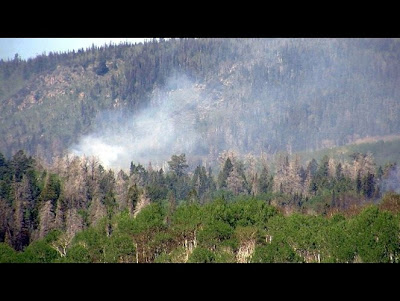 |
| Utah Wildfire |
The forecast? The next week looks substantially drier, with only a few light showers, and temperatures should be near normal or a bit on the cool side….but clearly not as bad as the last week.
You Might Also Like Our Friends' Posts
Comments are closed for this story.



 Choosing from the best US Canadian and international sources, we gather and select weather stories from around the world. World Weather Post not only brings you breaking news about people affected by weather, but also provides insight on how weather is affected by people. You will also find a sense of humour and a curiosity for understanding the weather, climate change and the environment. World Weather Post, where everybody talks about the weather.