
The Other Snow Story
During the past several days, this blog was been fixated on lowland snow and ice. Later I would like to talk more about the ice storm, which has been one of the major meteorological disasters of the past decade, with roughly 300,000 customer losing power, massive loss of trees, extensive road closures, and loss of life.
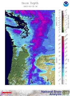
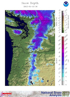
But another important weather story has been the huge inbcrease in snowpack over the past week, particularly at lower elevations and the Oregon Cascades. Below is the NOAA snowdepth graphics comparing January 13th to today. Big increases. Enough to make ski operators and outdoor enthusiasts smile.
A week ago, the Oregon snowpack (snow water equivalent, the amount of water when melted in the snowpack) was only around 35% and the Washington snowpack had dropped to below normal (70-90%). Below is the situation yesterday (click on image to enlarge). 85-100% for Washington and now 50% in southern Oregon to around 80% in the north. Big improvement.
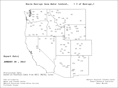
In contrast, there is a real serious snow drought in California, with stations in the Sierra’s at 10-15%. 6-12 inches new around Tahoe today….they need it. Utah and Colorado are also well below normal. Folks in those states like to smirk and criticize our snow. Not this year.
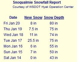
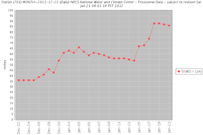
The Cascade passes have enjoyed a lot of snow (3-4 feet), roughly doubling their snow depth. Here are the Snoqualmie totals. Roughly doubled during the past week.
And here is the snow depth graphs for Ollalie Meadows (near Snoqualmie) and Stevens Pass. Major jumps in snow the past week.
 |
| Ollalie Meadows |
 |
| Stevens |
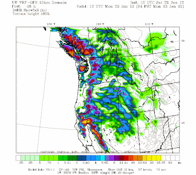
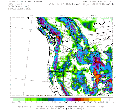
According to the latest model runs, the increase in show should continue, but at a lesser rate. Here are the snowfall predictions for the 24h periods ending Sunday and Monday at 4 AM. 6-18 inches of snow. And good news for CA: more snow for the Sierra’s. And yes, those smug folks in Utah will get quite a bit.
One final thing.
With all this snow the avalanche danger in the Cascades is quite high. First we had an extended period of relative cool conditions and little snow. That resulted in the formation of a surface crust. Then starting about a week ago we had a lot of snow under cool conditions. That produces low-density, fluffy snow. Perfect for skiing…Cascade powder! (Utah snow boosters take note!).
Over the past few days temperatures aloft warmed and there was lots of wetter, denser snow. So we have dense snow, over light snow, over a crust that acts as a ball-bearing for the upper layers to slide off of. That implies serious avalanche danger, and my colleagues at the Northwest Avalanche Center and the National Weather Service have warnings out. Back country skiing might not be a great idea today, and I would not be surprised if there is some avalanche work for some state highways.
You Might Also Like Our Friends' Posts
Comments are closed for this story.




 Choosing from the best US Canadian and international sources, we gather and select weather stories from around the world. World Weather Post not only brings you breaking news about people affected by weather, but also provides insight on how weather is affected by people. You will also find a sense of humour and a curiosity for understanding the weather, climate change and the environment. World Weather Post, where everybody talks about the weather.