
Strong Thunderstorm Hits Portland
For the second day in a row, the convection and thunderstorms developed over the Cascades and rolled into the western lowlands…in this case hitting southwest Washington, Portland, and the northern Willamette Valley. Mark Albright, past WA state climatologist, reported that an observer in downtown Vancouver just W of I-5 reported 0.40 inches of rain in 5-minutes from 19:29 to 19:34 PDT 26 May 2012. The highest hourly amount from the Portland Hydra network (46 sites) seemed to be the 1.34 inches over one hour from 19:00 to 20:00 PDT reported at Hayden Island just west of I-5.
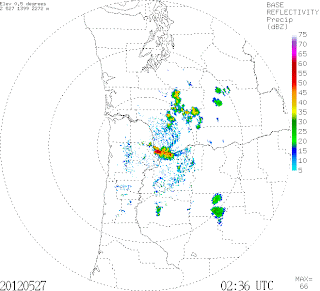
Take a look at the Portland radar at 7:26 PM Saturday….see those reds?…that is torrential rain.
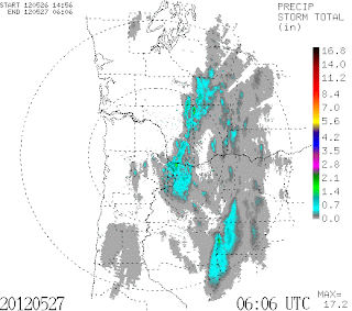
Here is the storm total precipitation from the radar…you can see the track of the heavier rainfall.
You Might Also Like Our Friends' Posts
Comments are closed for this story.



 Choosing from the best US Canadian and international sources, we gather and select weather stories from around the world. World Weather Post not only brings you breaking news about people affected by weather, but also provides insight on how weather is affected by people. You will also find a sense of humour and a curiosity for understanding the weather, climate change and the environment. World Weather Post, where everybody talks about the weather.