
Heavy Rain, Mountain Snow Bound for Mexico
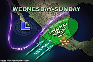
Indications are a storm will plow into Mexico later this week to spread rain over a large part of the nation during an unusual time of the year.

By Alex Sosnowski, Expert Senior Meteorologist
Feb 6, 2012; 12:55 PM ET
Essentially, this storm would bring from one to three winter season’s worth of rainfall and mountain snow.
Typically the period from late fall to the early spring is a dry time of the year for the region. Much of Mexico receives the bulk of its yearly rainfall from warm season-driven showers and thunderstorms spanning late May into early October.
A storm riding in from the central Pacific Ocean will plow southward later this week and may set up shop for a several-day period over central and southern Mexico.
From this position, the storm should be able to pump beneficial moisture over the a significant part of the nation from the last part of this week into the weekend.
While the details as to which areas will benefit the most from the wet pattern are unclear, there is potential for several tenths to an inch of rain in many locations. Several inches of rain could fall in portions of central and northeastern Mexico.
Rainfall for the entire month of February tends to be on the order of one to several tenths of an inch with less than an inch of rain falling on average for the entire winter season.
Portions of Mexico have been in a multi-year drought with rainfall even lacking during the wet season.
It is possible Mexico City (at an elevation of 7,300 feet) may receive snow from the storm. There is a more remote possibility that snow will fall in Guadalajara (at an elevation of 5,000 feet).
A few feet of snow could fall over the highest elevations of the Sierra Madre.
While the storm will be mostly beneficial, there is a slight risk of too much rain in a few places. This would generally only occur if the storm’s heavy rain is focused over the same area for a few days, or if a complex of thunderstorms were to develop, unloading a few inches of rain in a matter of hours.
The system due to move into Mexico later this week is not associated with the system brushing South Florida and the Bahamas today. However, it is part of the same system that will bring beneficial rain to much of California over the next couple of days.

It could be sign that the southern branch of the jet stream is ready to play a more active role with storms in the U.S. during the latter part of the winter.
The jet may add subtropical moisture to the storms farther north, perhaps giving them a boost in intensity and precipitation output.
You Might Also Like Our Friends' Posts
Comments are closed for this story.

.jpg)


 Choosing from the best US Canadian and international sources, we gather and select weather stories from around the world. World Weather Post not only brings you breaking news about people affected by weather, but also provides insight on how weather is affected by people. You will also find a sense of humour and a curiosity for understanding the weather, climate change and the environment. World Weather Post, where everybody talks about the weather.