
Great Lakes Wide Open for More Snow

The top image shows snow cover as of early Thursday, Jan. 12, 2012. The bottom image shows snow cover as of early Saturday, Jan. 14, 2012.

By Andy Mussoline, Meteorologist
Jan 14, 2012; 11:07 AM ET
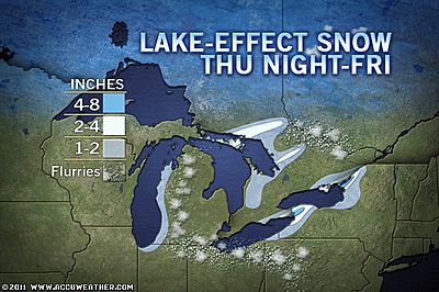
A lack of ice across the Great Lakes leaves a wide-open window of opportunity for lake-effect snow events for the balance of the winter. The last couple of days were no exception as arctic air met the relatively warm lakes, but we expect the snow to diminish across the lakes through Sunday.
Arctic air plunged into the eastern half of the country this week. A winter storm moved northeast through the Great Lakes Thursday into Friday while cranking up the lake-effect snow machine as the storm pulled away.
The storm left a blanket of snow across the region after a snow drought for the first part of winter.
A high pressure system sinking south into the Great Lakes will bring lighter winds and gradually shut off the lake-effect snow through Sunday. Flurries and snow showers will taper off to tranquil weather for the majority of the lakes by Sunday afternoon.

Additional flurries and snow showers through tonight in Buffalo, N.Y., will add a fresh dusting to the 7 inches of fresh snow that piled up since early Friday morning. Buffalo recorded more snow in 24 hours than the city recorded in all of winter through Thursday.
The latest round of wintry weather occurred as winter fights back into the country. Expert Senior Meteorologist Alex Sosnowski recently mentioned that the second half of winter may wield a double-edged sword around the Great Lakes, including Chicago.
Another storm is set to move through the Great Lakes by Tuesday. The storm is slated to bring a swath of light snow on Tuesday. With more cold air pouring over the lakes again with this next storm, the lakes could help to enhance the snow once again.
You Might Also Like Our Friends' Posts
Comments are closed for this story.



 Choosing from the best US Canadian and international sources, we gather and select weather stories from around the world. World Weather Post not only brings you breaking news about people affected by weather, but also provides insight on how weather is affected by people. You will also find a sense of humour and a curiosity for understanding the weather, climate change and the environment. World Weather Post, where everybody talks about the weather.