
Substantial Snow in the Works from Plains to East
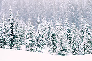
Parts of the Great Lakes and Northeast will once again turn into a winter wonderland later this week. Photo by Photos.com.

By Kristina Pydynowski, Senior Meteorologist
Jan 11, 2012; 8:00 AM ET
Winter is in the process of making a comeback across the eastern two-thirds of the U.S. with a far-reaching blast of colder air and the return of substantial snow in the works.
Far-Reaching Cold Shot
The storm system marking winter’s return will spend today plunging southward through the Plains, erasing Tuesday’s record warmth from the Upper Midwest.
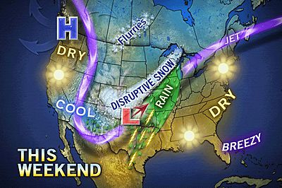
The noticeably colder air will continue to spread all the way to the Gulf and East coasts through Friday, shaving a general 10 to 30 degrees off high temperatures from the previous day.
Blustery winds ushering in the chilly air will create even colder and, in some cases, dangerous AccuWeather.com RealFeel® temperatures.
Winter is not only making a comeback in terms of frigid temperatures, but also substantial snow that will not just be confined to the typical snowbelts downwind of the Great Lakes.
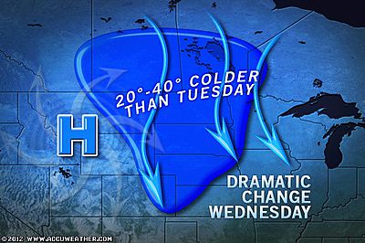
Wind-Whipped Snowstorm Eyes Chicago, Western Great Lakes
A bit of snow accompanying the cold air invading the Upper Midwest today will evolve into a more disruptive and wind-whipped snowstorm over the western Great Lakes on Thursday.
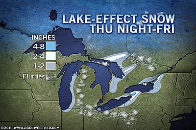
Up to a foot of snow will blanket most areas around Lake Michigan.
With the AccuWeather.com Winter Weather Center expecting a total of 3 to 6 inches, Thursday will easily be Chicago’s snowiest day of the season. The city has picked up a mere 1.9 inches so far this winter.
Quick-Hitting Snow, Squalls Threaten the Appalachians
Another band of snow will develop and press northward from the spine of the Appalachians to the eastern Great Lakes late on Thursday into Thursday night.
This snow will be quick-hitting, accumulating several inches in less than six hours. Blinding squalls threaten to worsen the situation for motorists by rapidly reducing visibility.
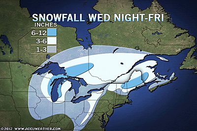
For a larger version of this map, visit the AccuWeather.com Winter Weather Center.
While creating headaches and nightmares for travelers, the impending snow is great news for snow enthusiasts and ski resort operators.
Snow, Wintry Mix Returns to the Northeast Starting Late Today
Before both snow events commence, snow and an icy mix is in store for the Northeast from northern Pennsylvania to northern New England later this afternoon into Thursday.
The wintry weather will transpire from the rainmaker currently invading the South.
Temperatures will remain too warm for snow to make an appearance when the rain reaches the I-95 corridor from Washington, D.C., to New York City, but flash flooding in poor drainage areas is a concern.
Prior to this week, the winter has been relatively tame across the eastern two-thirds of the nation in the wake of the historic late-October snowstorm.
Unseasonably warm air has been in control much of the past couple of months with only a few bouts of cold and snow. So far, West Texas and New Mexico has endured the worst of winter.
Once winter makes its comeback this week, AccuWeather.com Expert Senior Meteorologist Alex Sosnowski expects that it will not be quick to depart the Northeast.
“Cold air has been in and out during much of the winter thus far in the Northeast, like low tide on the beach.”
“The cold push coming in this weekend and those that follow may be more like the waves leading up to high tide. The waves of cold air may just keep coming, thanks to an anticipated major shift in the jet stream.”
You Might Also Like Our Friends' Posts
Comments are closed for this story.



 Choosing from the best US Canadian and international sources, we gather and select weather stories from around the world. World Weather Post not only brings you breaking news about people affected by weather, but also provides insight on how weather is affected by people. You will also find a sense of humour and a curiosity for understanding the weather, climate change and the environment. World Weather Post, where everybody talks about the weather.