
Hurricane Rina weakens as it slides toward the Yucatan
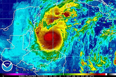
Despite its ragged appearance and obvious weakening, Hurricane Rina is still expected to bring heavy rain and strong wind gusts to the Yucatan Peninsula. Wind speed on Cozumel had been steadily increasing since this morning, though have leveled off in the past few hours. Wind speed will increase again soon as Rina moves closer to the island. This station has also reported 3.25 inches of rain so far, but like Jeff said in this morning’s blog, surrounding personal weather stations have only reported up to an inch of rain. Cancun’s radar shows Rina’s outer bands moving over the peninsula, and strong rain was reported in the city earlier this afternoon. A Yucatan Basin buoy is reporting wind speeds close to 30 mph, and waves around 8 feet so far. Having seen some photos of the Cancun beaches, wave height has increased there, as well, although aren’t near 8 feet quite yet.

Figure 1. Hurricane Rina’s wind analysis from NOAA’s Hurricane Research Division.

Figure 2. Visible satellite image of Hurricane Rina taken at 4:31pm EDT.
Forecast for Hurricane Rina
The forecast for Rina remains mostly in line with earlier forecasts, although the intensity has been decreased significantly and the track through Friday has shifted slightly to the east. Rina will continue to move north-northwest toward Cozumel over the next 24 hours, likely making landfall Thursday afternoon and evening. Beyond this, the models have changed their tune since yesterday. The ECMWF, GFS and HWRF are all forecasting Rina to weaken significantly after coming in contact with the Yucatan Peninsula, but instead of a forecast track toward southern Florida, they are now calling for Rina to linger in the Caribbean as a broad area of low pressure and disturbed weather until the middle of next week, when it finally is swept out by a trough. The official forecasts from the National Hurricane Center have conveyed this possibility well in the 4 and 5 day track forecasts so far. This afternoon, they’re calling for Rina to weaken to a tropical storm after landfall, at which point it will begin its clockwise turn back into the Caribbean while weakening further to a depression. The forecast surge has decreased to 2 to 4 feet, likely due to both the weakening of the hurricane and its relatively small wind radius, and heavy rain and flooding are still a concern for the Yucatan and Cozumel.
Jeff will be back with a morning post tomorrow.
Angela
You Might Also Like Our Friends' Posts
Leave a Reply




 Choosing from the best US Canadian and international sources, we gather and select weather stories from around the world. World Weather Post not only brings you breaking news about people affected by weather, but also provides insight on how weather is affected by people. You will also find a sense of humour and a curiosity for understanding the weather, climate change and the environment. We encourage you to use our blog to express your opinion and share your stories and knowledge. World Weather Post, where everybody talks about the weather.