
Hurricane Rina: Cancun in Danger, Florida on Alert
Hurricane Rina: Cancun in Danger, Florida on Alert
Oct 26, 2011; 7:30 AM ET
Powerful Hurricane Rina is on a collision course with Mexico’s Yucatan Peninsula then could impact the Florida Peninsula.
Rina remains a dangerous storm in the northwestern Caribbean, churning less than 400 miles off the coast of the Yucatan Peninsula.
Rina is on the verge of becoming a major hurricane (Category 3 strength or greater) and could reach that status later today or tonight.
However, the severity of the situation facing the Yucatan Peninsula will not change whether Rina slams onshore as a strong Category 2 or minimal Category 3 hurricane.
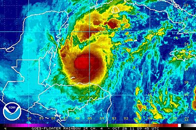
This satellite image of Hurricane Rina, courtesy of NOAA, was taken earlier this morning.
In either case, lives and property will be threatened as Rina unleashes destructive winds, flooding rain and a dangerous storm surge.
Tropical storm-force winds and the outer rain bands of Rina will reach the eastern shores of the Yucatan Peninsula this afternoon, followed by increasing rain and wind tonight.
Thursday is when the worst of Rina will pound the Mexican states of Quintana Roo and eastern Yucatan.
Cities in Rina’s direct path, including the popular resort cities of Cozumel and Cancun, are bracing for powerful winds capable of causing widespread tree and window damage and lengthy power outages.
Poorly constructed homes face significant damage, while even structurally-sound homes and businesses may not emerge from the storm unscathed.
“The hurricane will unleash rainfall amounts of 6-10 inches as it moves at a crawling pace,” stated AccuWeather.com Meteorologist Meghan Evans.

Fishermen secure their boat in anticipation of Hurricane Rina’s arrival in Cancun, Mexico, Tuesday, Oct. 25, 2011. (AP Photo/Israel Leal)
“Since the terrain is relatively flat, the threat of significant urban flooding exists,” stated World Weather Expert Meteorologist Jim Andrews.
The immediate coastline also faces flooding from pounding surf, which includes an expected storm surge of 5 to 7 feet above normal tide levels along and to the right of where Rina comes onshore.
Rina will weaken as it crosses the Yucatan Peninsula and emerges into the southern Gulf of Mexico by Friday.
After Friday, Rina could loop southward into western Cuba or the northwestern Caribbean or take a track toward the Florida Keys or South Florida this weekend.
While the latter could mean a damaging wind threat for South Florida, Rina’s moisture will stream northward in both solutions and lead to downpours across central or South Florida later this week into early next week.
Such downpours would definitely result in ruined vacation plans and possible urban flooding.
Until Rina’s track is set in stone, all residents and visitors across the Florida Peninsula should check back with the AccuWeather.com Hurricane Center to monitor Rina’s progress.

By Kristina Pydynowski, Senior Meteorologist
You Might Also Like Our Friends' Posts
Comments are closed for this story.


 Choosing from the best US Canadian and international sources, we gather and select weather stories from around the world. World Weather Post not only brings you breaking news about people affected by weather, but also provides insight on how weather is affected by people. You will also find a sense of humour and a curiosity for understanding the weather, climate change and the environment. World Weather Post, where everybody talks about the weather.