
Jet Stream Weather
As many of you know, the jet stream is a current of strong winds—much narrower than its length–that is often found in the upper troposphere–typically between 25,000 and 35,000 ft. The jet stream is associated with major weather systems– the wind and rain storms that strike the region– particularly in the winter. Jet stream winds can reach over 200 mph, and can greatly accelerate or retard the motion of jet aircraft, depending whether they are heading east (fast trip) or west (long trip). The jet streams are from the west in the midlatitudes (the midlatitude “jet”).
The jet stream was first described by German meteorologists in the 1930s and this feature become very obvious to pilots on bombing missions during World War II. The jet stream is generally strongest in the mid-Pacific and some missions directed at Japan found themselves making little headway to the west at times.
During a typical year the jet stream core is north of the Northwest in late summer and then slides down into our area in late October and November. Think of the jet stream as an atmospheric hose and we are on the receiving end during November through January.
Today and Saturday the jet stream will dip down close to us… let me show you. The following charts present the wind speed (in meters per second, roughly double for knots or mph, by colors) at a pressure level of 300 mb (roughly 30,000 ft). Here is a forecast for today at 2 PM. Strong jet over the Pacific that is approaching northern Washington, with values well over 100 kts.

Tomorrow the jet pushes in just to our north

This weekend we will be hit by some disturbances riding on the jet, particularly on Saturday.
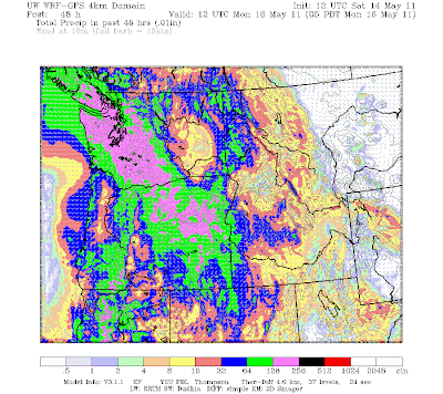
Here is the 24-h predicted rainfall charts end Saturday, Sunday, and Monday at 5 AM.
Ending 5 AM, we see modest amounts over western Washington reaching 1-2 inches on the western slopes of the northern part of the State.

A second system gets here Saturday morning and as you will see, the rainfall, particularly in the mountains is far more serious (1-2 inches being widespread)–see map below for 24-h rainfall ending Sunday at 5 AM. Bad for hiking! But you can escape the rain on Saturday by heading to eastern Washington or by positioning yourself in the rainshadow to the NE of the Olympics.

Finally the 24-h rain ending 5 AM on Monday is unimpressive…some light showers, with much of the western lowlands and eastern WA being dry. Sunday is the better day for outdoor activities.

And talking about outdoor activities, the annual Dawg Dash will take place on Sunday at the University of Washington at 9:30 AM (http://www.promotionevents.com/dawgdash/). It will probably be cloudy with a few sprinkles, but nothing compared to the deluge of last year!
You Might Also Like Our Friends' Posts
Comments are closed for this story.




 Choosing from the best US Canadian and international sources, we gather and select weather stories from around the world. World Weather Post not only brings you breaking news about people affected by weather, but also provides insight on how weather is affected by people. You will also find a sense of humour and a curiosity for understanding the weather, climate change and the environment. World Weather Post, where everybody talks about the weather.