
Flooding, Gusty Storms Target Midwest, Northeast


By Bill Deger, Meteorologist
Aug 7, 2011; 6:05 AM ET
“With a wide region exposed to high levels of atmospheric moisture, flooding downpours will be a staple of most scattered showers and storms…”
More rounds of drenching showers and storms will finish off the weekend across parts of the Midwest and Northeast, sure to impact many planned outdoor activities.
A few of the storms could turn severe as well, thanks to a warm and moisture-rich air mass in place.
The main threat, however, will be from prolonged heavy rain and flooding from slow-moving showers and storms, as was seen earlier in the weekend.
More Flooding Rain Likely
On Saturday, more than 4 inches of rain fell in separate complexes of showers and storms that impacted the Harrisburg, Pa., area, parts of northern Virginia and the Raleigh/Durham area. Many more locations scattered about the Midwest and mid-Atlantic recorded 1 to 3 inches of rain in a short amount of time from storms.
Today, AccuWeather.com meteorologists are targeting the I-95 corridor from near Baltimore north to New York City as the region especially susceptible to flooding from thunderstorm downpours.
Because many in this region experienced heavy rain on Saturday and overnight, the threat for flooding in low-lying and poor drainage areas will be elevated as any heavy shower or storm rolls through.
However, with such a wide region exposed to high levels of atmospheric moisture, flooding downpours will be a staple of most scattered showers and storms as they develop throughout the day.
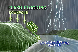
Many of the areas threatened by flooding today have been abnormally dry so far this summer, thus a hard ground will precipitate quick and excess runoff of rainwater which could overwhelm drainage.
Never drive through flooded roadways and be sure to slow down during heavy rain, as visibilities will quickly drop, especially around and behind large vehicles and tractor trailers.
Homeowners will want to keep an eye on their basements and water levels of nearby creeks and streams, and be prepared to evacuate to higher ground at the first sign of flooding.
Severe Weather Threat
A minority of the storms will also exhibit signs of turning severe, capable of producing damaging wind gusts and hail, as well as continuous lightning.
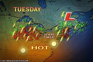
Parts of the Great Lakes and Midwest, including Detroit, Chicago, Toledo and Indianapolis, will be at greatest risk for severe weather today, as indicated by Meteorologist Brian Edwards.
Edwards points out that the greatest threat from the strong storms will be large hail and wind gusts greater than 60 mph.
With an unstable air mass also in place over the Ohio Valley and mid-Atlantic, an isolated severe storm cannot be ruled out in these areas as well.
Unfortunately for those with outdoor plans to begin the workweek, the threat for heavy rain and thunderstorms will continue into Monday. For some returning to work, this type of weather could turn out to be appropriate.
You Might Also Like Our Friends' Posts
Comments are closed for this story.




 Choosing from the best US Canadian and international sources, we gather and select weather stories from around the world. World Weather Post not only brings you breaking news about people affected by weather, but also provides insight on how weather is affected by people. You will also find a sense of humour and a curiosity for understanding the weather, climate change and the environment. World Weather Post, where everybody talks about the weather.