
Hotting Up in the Far East
Hotting Up in the Far East
Jun 23, 2011; 12:30 PM ET
TROPICAL STORM MEARI, TROPICAL DEPRESSION HAIMA
Tropical Storm Meari (07W) is slowly gathering east of northern Philippines (Luzon). Today’s satellite imagery seems to show northerly wind shear, which would account for the slow rate of strengthening.
Numerical forecast models (GFS and others, 0000 and 1200 GMT Thursday) that I have seen show substantial deepening of the low over the next 24-36 hours. This could be enough to lift Meari to typhoon status, at least for a short interval.
Earlier disagreement has given way to fairly broad agreement as to path and timing. The broad scenario is that Meari should track northward between Taiwan and Okinawa Friday, then head for a landfall in western (or southern) Korea late Saturday into Sunday.
A direct landfall will be possible on the southwestern Ryukyu Islands (Sakishima Shoto) Friday; otherwise, first landfall would seem to be on the Korean Peninsula.
I believe widespread heavy rain and flooding on the Korean Peninsula (this weekend) to be the most serious potential impact of Meari.
While there will be no landfall by Meari on the Philippines, it will have a significant bearing upon rainfall for the archipelago. Already, there have been heavy falls of rain in many places, including greater Manila. This heavy rain is, in some ways, a continuation of rain from TD 06W (Haima), which left its share of cloudbursts. Cubi Point, western Luzon, has had something over 75 cm of rain within the last week.
Deeply moist southwesterly flow spiraling towards Meari, even as it pulls well away to the north, will wring out more torrential rain over the Philippines during the next few days. Western Luzon will be at greatest risk of excessive rain, flooding and mudslides.
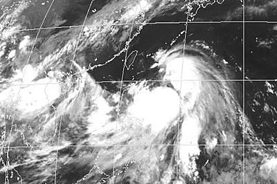
T.D. Haima (06W, west) and T.S. Meari (07W) as of June 23, 2011 (Japan Meteorological Agency image).
As for Haima (06W), it has been downgraded to a tropical depression following a landfall in south China (Luichow Peninsula, Guangdong). Movement has been westward.
Numerical forecast scenarios have shown a path across the northern Gulf of Tonkin to northern Vietnam Friday into Saturday. This scenario could see Haima regain storm status before making its last landfall.
Haima will likely trigger flooding in areas along and near its path.
HEAVY RAIN IN N. CENTRAL INDIA
The strong monsoon low that landed at the head of the Bay of Bengal last week has persisted as of Thursday. Its latest stroke was to pour 35 to 40 cm of rain on Guna, in northernmost Madhya Pradesh. Most of this fell within an 18-hour stretch ended Thursday morning, local time.
In Rajasthan, Kota (15 cm) and Jaipur (5 cm) have had their first big rains of the season (and 2011).
You Might Also Like Our Friends' Posts
Comments are closed for this story.


 Choosing from the best US Canadian and international sources, we gather and select weather stories from around the world. World Weather Post not only brings you breaking news about people affected by weather, but also provides insight on how weather is affected by people. You will also find a sense of humour and a curiosity for understanding the weather, climate change and the environment. World Weather Post, where everybody talks about the weather.