
Madagascar Facing Cyclone Threat
Madagascar Facing Cyclone Threat
Jan 7, 2012; 12:39 PM ET
TROPICAL LOW PRESSURE IN THE MOZAMBIQUE CHANNEL
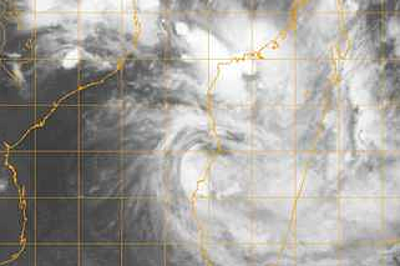
Tropical low pressure has formed in the Mozambique Channel, where it could become an important tropical cyclone before potentially crossing the shores of western Madagascar Sunday or Monday.
Already, as of Saturday, locally heavy rain has pelted both sides of the channel, mostly in the northern halves of Madagascar and Mozambique, this week. Likewise, the Comoros Islands have been dosed.

Tropical Low Pressure in the Mozambique Channel as of 1700 GMT Saturday, Jan 7, 2012 (Navy Research Lab Monterrey)
Satellite imagery on Saturday has shown deep convective rains reaching well northwest into Africa, likely along the southern edge of the regional Monsoon. This stream seems to have been feeding the gathering low.
On Friday, the Joint Typhoon Warning Center (JTWC) plotted the center of low pressure within 50 to 100 miles of central Mozambique. Now, as of Saturday afternoon, local time, the low’s center seems to be over the middle of the southern Mozambique Channel, drifting southeastward.
FLASH FLOODING GREATEST HAZARD
Landfall in Madagascar looks set to happen near, if not between, Morombe and Morondava, Madagascar.
A slower forward speed could favor a stronger storm, as sea surface temperature in the likely path of this low is about 29 degrees C as of early Friday.
Barring explosive deepening to a storm of hurricane intensity, the greatest hazard stemming from this tropical weather system will be that of flash flooding. I believe that western Madagascar north the low’s path, together with southeastern Madagascar, will be at greatest risk of excessive rain and serious flooding through the middle of next week.
Historically, Madagascar has suffered serious flash flooding during its summer rainy season, especially in the drier, scrubby western side of this huge island. A rough estimate is that highest falls of rain will be between 8 and 16 inches (200 and 400 mm) through the first half of the week.
You Might Also Like Our Friends' Posts
Comments are closed for this story.



 Choosing from the best US Canadian and international sources, we gather and select weather stories from around the world. World Weather Post not only brings you breaking news about people affected by weather, but also provides insight on how weather is affected by people. You will also find a sense of humour and a curiosity for understanding the weather, climate change and the environment. World Weather Post, where everybody talks about the weather.