
Category 4 Kenneth the strongest East Pacific late-season hurricane on record
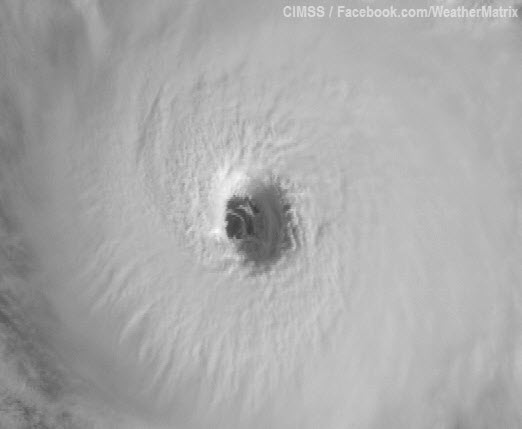
Kenneth is over 27°C waters and under light wind shear of 5 – 10 knots, so could conceivably intensify further. However, I expect the storm has peaked, since it’s tough for a hurricane to get much stronger than Kenneth’s current intensity with ocean temperatures so close to the 26.5°C hurricane formation threshold. Satellite loops show an impressive storm with a large eye, good symmetry, and plenty of upper-level outflow. The relative lack of spiral bands and large, thick eyewall may qualify Kenneth to be a rare breed of hurricanes known as “annular”. Annular hurricanes are a subset of intense tropical cyclones that are significantly stronger, maintain their peak intensities longer, and weaken more slowly than average tropical cyclones. The latest SHIPS model output indicates that Kenneth has passed the initial screening step to be considered an annular hurricane. Only 4% of all hurricanes are annular hurricanes.

Figure 1. Morning satellite image of Hurricane Kenneth.
Unnamed tropical storm from September 2 brings the Atlantic’s 2011 tally to 19
Re-analysis has shown that a tropical disturbance that formed between Bermuda and Nova Scotia on September 2 briefly attained tropical storm status, according to an article posted yesterday by Ken Kaye at SunSentinel.com, quoting NOAA’s lead seasonal hurricane forecaster Gerry Bell. The addition of the unnamed tropical storm to the record books brings this year’s tally of named storms to nineteen, tying 2011 with 2010, 1995, and 1887 as the 3rd busiest year for tropical storms. Only 2005 and 1933 had more named storms since record keeping began in 1851. An average season has just eleven named storms. Here’s my blog entry from September 2 on the unnamed tropical storm:
A well-organized low pressure system with a surface circulation but limited heavy thunderstorm activity due to high wind shear is 450 miles south of Halifax, Canada. This disturbance, (94L), is headed northeast out to sea, and is being given a 60% chance of developing into a tropical depression by NHC. 94L is under a high 25 – 30 knots of wind shear, but this shear is expected to fall to the moderate range, 10 – 20 knots, by Saturday morning. However, sea surface temperature will fall from 27°C today to 25°C Saturday morning underneath 94L, and the storm will have a very short window of time to get organized enough to get a name. At this point, it’s really a subjective judgement call on whether or not 94L is already a tropical storm.
In addition, the Atlantic has gained one more hurricane for the year, as Nate was upgraded to a hurricane in post-season analysis. Nate hit Mexico’s Bay of Campeche coast near Veracruz on September 11 as a weak tropical storm. The storm killed five people and caused minor damage near Veracruz. Nate brings this year’s tally of hurricanes to seven, one hurricane above average.

Figure 2. True-color MODIS image of Tropical Storm Nate taken at 12:45 pm EDT Friday, September 9, 2011. At the time, Nate was a tropical storm with 50 mph winds. Image credit: NASA.
Invest 99L in the Atlantic moving over colder waters
In the Atlantic, Invest 99L, an extratropical storm in the middle Atlantic that is generating tropical storm-force winds, has moved over colder waters of 24°C and is looking less tropical than yesterday. The storm is moving northeastwards out to sea and over even colder waters, and is not a threat to any land areas. NHC is giving 99L a 10% chance of becoming a named subtropical storm.
Jeff Masters
You Might Also Like Our Friends' Posts
Comments are closed for this story.




 Choosing from the best US Canadian and international sources, we gather and select weather stories from around the world. World Weather Post not only brings you breaking news about people affected by weather, but also provides insight on how weather is affected by people. You will also find a sense of humour and a curiosity for understanding the weather, climate change and the environment. World Weather Post, where everybody talks about the weather.