
Impressive Rain, Waves, Damage From Unnamed Storm
Impressive Rain, Waves, Damage From Unnamed Storm
Oct 11, 2011; 11:02 AM ET
The unnamed subtropical storm off the coast of Florida sure brought a lot of havoc over the weekend. One wonders if it were named, would people have been better prepared? On the other hand, you can’t name every low pressure system. We interviewed the National Hurricane Center for comment yesterday and may be publishing a story on that today. I will present only the meteorological facts.
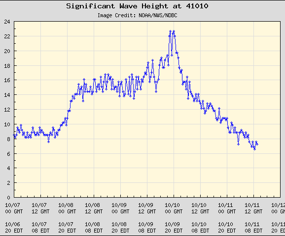
Buoy #41010 off the central Florida coast measured waves of 23 feet (even close to shore) and damage were starting to be reported by numerous users of a cruise ship Forum (thanks Mark for the link). Kathy from that Forum had a friend who was on the “Freedom” that left Port Canaveral:
“The galley was trashed and we had to stop dishes from sliding off the table… Captain ordered everyone to their staterooms… At about 10:30 [Sunday Night] they offered a buffet setup with paper plates… The tv reported 80+ mph wind. Stores on the promenade had a lot of debris from things crashing to the floor.”
A storm surge over 2 feet caused flooding in Jacksonville yesterday morning.
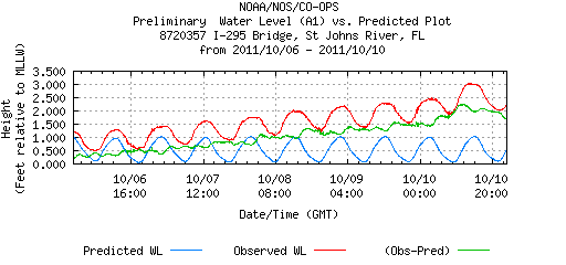
At Vilano Beach, waves reached 10 feet and moderate beach erosion was reported. Other NWS reports included:
“FLOODING FROM HEAVY RAINFALL AND COASTAL FLOODING REPORTED AT LASALLE AND PALM AVES… WATER OVER TOP OF SEAWALL IN EAST PALM COAST…RELAYED BY EMERGENCY MANAGER.”
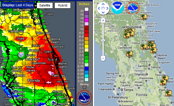
The NWS also received more than a dozen reports of wind damage, including these:
“FLAGLER COUNTY DISPATCH HAD MULTIPLE REPORTS OF TREES AND POWER LINES DOWN COUNTYWIDE… MULTIPLE TREES AND POWER LINES ARE DOWN FROM THE NORTH END OF OCALA; A TREE IS DOWN ON A VEHICLE WITH ENTRAPMENT AT 4491 NW 27TH AVENUE.. .SNAPPED A POWER POLE… AND TWISTED TREES IN THE COMMUNITY OF TAVERNIER… 1.5 FOOT DIAMETER TREE DOWN ACROSS VEHICLE AND WRAPPED IN POWER LINES AT 300 BLOCK OF COQUINA AVE. IN ORMOND BEACH…”
Nearly a foot of rain was received in northern Florida (one CoCoRAHs observer measured 11.49″ in Suntree). And additionally, two tornadoes were reported (which would typically happen when a tropical storm was passing by). Reports of coastal flooding and tornadoes are plotted below.
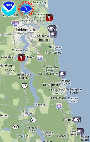
“STORM SURVEY ESTIMATED PEAK WINDS AT 80 MPH WITH THE TORNADO WHICH CAME ONSHORE FROM THE ST JOHNS RIVER NEAR HEAD RD AND CROSSED PINE AVE INTO THE HARVEST BEND SUBDIVISION…. PARK/FOREST SRVC PARK OFFICIAL REPORTED POSSIBLE TORNADO WITH SEVERAL TREES DOWN BLOCKING FORT GEORGE ROAD AND PALMETTO ROAD NEAR MAYPORT. A MOBILE HOME SUSTAINED MINOR DAMAGE WITH AWNING TORN OFF.”
You Might Also Like Our Friends' Posts
Comments are closed for this story.


 Choosing from the best US Canadian and international sources, we gather and select weather stories from around the world. World Weather Post not only brings you breaking news about people affected by weather, but also provides insight on how weather is affected by people. You will also find a sense of humour and a curiosity for understanding the weather, climate change and the environment. We encourage you to use our blog to express your opinion and share your stories and knowledge. World Weather Post, where everybody talks about the weather.