
Tropical Concerns for Leewards, Bermuda, Canada

Two tropical waves that recently emerged off of the African coast bear watching. Time will tell if they overcome pockets of dry air and wind shear. They are both in a slot that would bring them up along the eastern coast of North America.

By Alex Sosnowski, Expert Senior Meteorologist
Aug 11, 2011; 10:50 AM ET
Two tropical systems forecast to soon form in the Atlantic could pass too close for comfort to the Leeward Islands, Bermuda and Atlantic Canada over the next couple of weeks.
As we have been saying here at AccuWeather.com, the Atlantic is locked and loaded with the potential for up to three named systems by August 25.
According to Tropical Weather and Hurricane Expert Dan Kottlowski, “At least two of these systems may become strong enough and whipped around by high pressure in the central Atlantic in such a way as to pass close to or over Bermuda.”
Next up could be the Canadian provinces somewhere from New Brunswick to Newfoundland, essentially the Gulf of St. Lawrence region.
The track, let alone formation of the two systems, is in no way set in stone. However, at this point we wanted to make folks aware of two potential troublemakers.
A shift in track is possible with one or both systems. That shift would bring them closer to, or farther away from, the Antilles, the Bahamas and the East Coast of the U.S.
As of late this week, the two systems were mere tropical waves cruising westward, relatively fresh arrivals from the African continent.
These systems, like many others before and after, will have to battle areas of wind shear and dry air, as revealed by dust originating from the Sahara Desert, along the way.
Interestingly, at least two long-range computer models are seeing the two systems at this early stage and developing them, bringing them around the Atlantic high pressure area, and driving them northward through the western Atlantic.
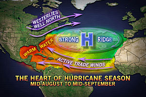
We are not saying the models have a 100 percent right idea on the storms and their supposed tracks, but we are relaying concerns we have in this matter.
On a personal note, I am not a fan of long-range computer model forecasts in the tropics. However, my 28 years of professional forecasting experience tell me that when two commonly used models are essentially predicting the same outcome with minor variances, the situation is worth watching.
If either of the two or both tropical waves slowly organize and become legitimate named tropical systems, they could become strong enough and large enough to have impact on populated areas.
Size, intensity and exact track of the systems will matter as far as local impacts. Even a weak system could bring a period of disruptive, heavy, gusty squalls to island areas such as the Leewards and Virgin Islands.
Both systems will pass nearby the Leeward Islands first. The first system is on track to approach and pass the Leewards spanning Sunday into Monday (Aug. 14 and 15). The second system is due to pass days later; Thursday into Friday of next week (Aug. 18 and 19).
Bermuda may have to deal with the first system spanning Tuesday into Wednesday. The second system would pass near Bermuda the weekend of Aug. 20 and 21.
Part of Atlantic Canada sticks out to the east hundreds of miles relative to the U.S. coast. As a result, at this early stage, people and interests from New Brunswick to Nova Scotia will need to monitor storm development in the tropical Atlantic. The first system would make its run at the region Thursday into Friday of next week (Aug. 18 and 19). The second system would be of concern for the region the week of Aug. 22.
Additionally, shipping and cruising interests will want to watch the situation closely, as the outcome currently most certain is for at least periods of rough seas in the western Atlantic.
Even if both storms were to stay east of the U.S., one or more episodes of rough surf and dangerous rip currents could occur.
Interestingly, it would not take much for an approaching dip in the jet stream to capture one or both systems in such a way as to pull them closer to the East Coast of the U.S.
You Might Also Like Our Friends' Posts
Leave a Reply


 Choosing from the best US Canadian and international sources, we gather and select weather stories from around the world. World Weather Post not only brings you breaking news about people affected by weather, but also provides insight on how weather is affected by people. You will also find a sense of humour and a curiosity for understanding the weather, climate change and the environment. We encourage you to use our blog to express your opinion and share your stories and knowledge. World Weather Post, where everybody talks about the weather.