
Arabian Sea Cyclone Threat Update
Arabian Sea Cyclone Threat Update
Jun 6, 2011; 12:26 PM ET
MAJOR CYCLONE OR ORDINARY MONSOON LOW — STILL TOO EARLY TO KNOW
It’s too early to know, as there is not yet a significant tropical low, nor is there anything near a consensus as to the coming status of the weather system.
To recap from the last post (Thursday), the potential for an Arabian Sea tropical cyclone has been suggested by no fewer than two numerical forecast models (the GFS foremost of these) since at least the middle of last week. Also indicated has been the three of extreme high rainfall along the Arabian Sea coast and western slopes of the Ghats.

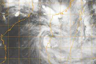
India Meteorology Department Kalpana-1 taken 1630 UTC Monday, June 6, 2011.
Now, as of Monday night, local time, a “cyclonic weakness” (for want of better wording) is set up along the leading edge of the advancing South West Monsoon off western India (Maharashtra). The India Meteorology Department (IMD) have “declared” the SW Monsoon through Mumbai (as of June 5-6).
Apparently, the northward track of the weakness has been farther west than had been indicated, the outcome being that extreme falls of rain have not thus far taken place. Rather, “manageable” falls of rain (locally near 30 cm since Thursday) have spread widely from Kerala north to Maharashtra.
Most important of all, however, is that the weakness has remained disorganized, lacking a good blow-up of convective rain at its core.
LATEST NUMERICAL FORECAST SCENARIOS
These are only two of a number of numerical forecast solutions that may be available. One is the GFS; the other, the NOGAPS.
As of 1200 UTC Monday, the GFS is still winding a major cyclonic low over the open north Arabian Sea. This is within 48 hours of initial time (this would be 1200 UTC Wednesday), well off to the west of Mumbai. Pressures are forecast below 960 mb within another 24 to 36 hours as the low is translated north and west.

GFS scenario of 1200 UTC Monday, June 6, shows powerful cyclonic low off SW Pakistan on 0000 UTC Sunday, June 12.
Landfall would be on the Makran Coast of Pakistan about Sunday morning, local time, according to the above scenario.
For reference, the scenario of 0000 UTC Monday showed a cyclone tracking to the Gulf of Oman before landfalling in southeastern Iran. Thus, this run shows a more easterly track.
The Makran track would imply serious threat of flooding rain in a desert land of bare earth and rock, having steep slopes.
Which GFS run is right? I do not know. Odds are good that neither is right.
The other forecast model, the NOGAPS, to be short, shows a low of possible cyclone strength within 48 hours (by 1200 UTC Wednesday). However, rather that a westerly track, this one shows a southeastward dip culminating in a landfall on the west coast (Karnataka or southernmost Maharashtra) by 60 hours (0000 UTC Thursday).
The NOGAPS scenario would imply a threat of excessive rain and even damaging winds along peninsular India’s west coast and western slopes.
Scenarios of GFS the NOGAPS are about as far apart as they could be, other than that both show that the threat of a tropical cyclone exists. I do not know which is the better solution, and I could “see” either scenario happening, more or less.
Anyways, the “cyclone watch” goes on. It is still a waiting game.
You Might Also Like Our Friends' Posts
Comments are closed for this story.



 Choosing from the best US Canadian and international sources, we gather and select weather stories from around the world. World Weather Post not only brings you breaking news about people affected by weather, but also provides insight on how weather is affected by people. You will also find a sense of humour and a curiosity for understanding the weather, climate change and the environment. World Weather Post, where everybody talks about the weather.