
Arabian Sea Cyclone Threat
Arabian Sea Cyclone Threat
Jun 2, 2011; 12:05 PM ET
SW MONSOON ONSET MAY GET BOOST FROM TROPICAL CYCLONE

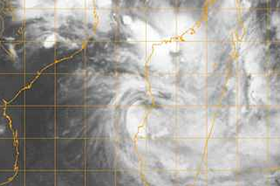
Infrafred satellite photo of the Arabian Sea, June 2, 2011. Credit: IMD.
It is June 2, and the leading edge of the SW Monsoon has reached northward into Karnataka state in southern India, according to the India Meteorology Department (IMD). Thus, all of Kerala and nearly all of Tamil Nadu have now witnessed the Monsoon onset. Timing is on schedule to a few days early, IMD maps show.
Not uncommonly, the Monsoon onset is raucous, being fraught with very heavy falls of rain, strong thunderstorms and even cyclonic disturbances of tropical storm strength.
Such a cyclone disturbance seems to be gathering at the writing near the Karnataka coast, site of the SW Monsoon advance.
The June 2, 1200 UTC, run of the GFS numerical forecast model, to chose one such forecast tool, shows slow evolution of a significant center of low pressure along the Western Ghats of Karnataka and southern Maharashtra Friday through Sunday.
Then, early next week, this forecast scenario shows a well marked low, maybe having tropical storm strength winds, slipping off shore near Mumbai Tuesday or Wednesday.
Taken literally, the scenario suggests a tropical cyclone landfall on the Kathiawar Peninsula of Gujarat state about Thursday.
WHAT WOULD BE THE IMPACT OF SUCH A WEATHER SYSTEM?
It should be made clear that the above scenario is even that–a scenario. Other forecast models and other runs of the GFS have shown different scenarios of timing and track. The June 2, 1200 UTC, NOGAPS forecast model has no significant low.
Anyways, I foresee further refining of the scenario going forward with no assurance that a tropical cyclone will take shape.
This said, the above scenario holds some threats to like and property in western India.
One such threat would be that of very heavy falls of rain potentially yielding flooding. It seems reasonable to me that amounts will reach 30 to 60 cm (about 12 to 24 inches) between the Arabian Sea coast and the Western Ghats. I would not rule out amounts of 90 cm (about 3 feet) by the middle of next week.
Winds of damaging potential would naturally hinge upon the intensity of the low. The present GFS scenario would bring potentially damaging winds from near-shore waters to the Western Ghats, mostly in Maharashtra and Gujarat.
Other forecast scenarios have suggested a more open-water track aimed northwestward south of Kathiawar and Pakistan. As I see things, it is too fully early to rule out such a track.
GONU WAS ACTIVE FOUR YEARS AGO
As I understand it, Super Cyclonic Storm Gonu was the strongest such storm known to happen in the Arabian Sea. I believe that highest sustained 1-minute winds (JTWC) were 150 mph–equivalent to a upper rank Category 4 Atlantic hurricane.
Gonu formed off western India on June 1, then deepened explosively westward over the open Arabian Sea. Its devastating landfall happened on June 5 over easternmost Oman, becoming this Arabian nation’s worst natural disaster. And it was the strongest such storm known to strike the Arabian Peninsula.
A second, last landfall took place from the Gulf of Oman in southeastern Iran, with further deadly effect.
You Might Also Like Our Friends' Posts
Comments are closed for this story.



 Choosing from the best US Canadian and international sources, we gather and select weather stories from around the world. World Weather Post not only brings you breaking news about people affected by weather, but also provides insight on how weather is affected by people. You will also find a sense of humour and a curiosity for understanding the weather, climate change and the environment. World Weather Post, where everybody talks about the weather.